| « PROFIL | CESTOVÁNÍ/AKCE | FOTOGALERIE | SHOW | ODKAZY | KONTAKT | |
|
The Three Peaks Challenge 20042nd & 3rd July 2004, Britain
© Michal Harsa, December 2004 We have found Internet very useful when looking for all sort of information about The Three Peaks Challenge. To help other 3peakers with their preparations, to make our friends, who have crossed their fingers for us, familiar with how it was or just for fun of broader audience, here is a web page describing our memorable experience and couple of facts about the 3peaks challenge.
What is 3peaks challenge about? The Three Peaks Challenge - an attempt to climb Ben Nevis in Scotland, Scafell Pike in England (in the Lake District) and Mount Snowdon in Wales within 24 hours (= to climb all the highest peaks within Britain’s countries). It means ascent, descent and transfer among these mountains within 24 hours limit. The Three Peaks Challenge is becoming very popular all over the UK. Thousands of climbers of any age and gender attempt the Three Peaks Challenge every year. Some of them as part of officially organized events often raising charity funds (participants/teams have to contribute some amount to a fund), some of them just at their own for fun or to prove to themselves that they are able to manage it. Rather than by individuals, people do the 3peaks challenge in small teams. If you/your team participates in an officially organized event, usually an organizer takes care about support activities such transport issues (you don’t have to necessarily drive a car – there are support team members who do that for you so you have a chance to have a rest during the transfers), basic refreshment and sometimes guides as well. Of course, usually you have to pay extra money for that. It depends. On the other hand independent teams enjoy planning everything on their own. They have often their support teams too – usually their spouses or friends. People typically do 3peaks during the summer weekends when there is a good chance to have good, warm weather and when there are long days (I mean a period between sunrise and sunset). Unfortunately you can find the peaks to be overcrowded a little bit at that time. Alternatively, if you are worried about that – why don’t you choose any other-than-the-bloody-most-famous peaks instead? By the way – there are many similar adventures all around the world. For instance Australian Three Peaks Race, The Magellan Three Peaks Yacht Race and many, many others. The Three Peaks Challenge is not easy but I reckon that well prepared and fit individuals can manage it if there is not a problem such a traffic jam or a car breakdown, bad weather conditions, getting lost or hundreds of other reasons... Hardly to say what a fail rate is. I have heard about teams that had to give it up, some of them being just a few minutes behind a 24 hours schedule or runners having a plenty time left. Personally, I would emphasize that’s not supposed to be a competition or a race. I believe that this should be about a remarkable experience, about exploring interesting places and performance beyond day-to-day life limits. So really “The Three Peaks Challenge is not winning but taking part”.
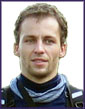
Once I sorted out basic facts I spoke to my friends and I was actually surprised how they were interested in and the idea easily agreed. We formed a team – me, Vitek and Petr (long-time standing friends and former school-mates), Zdenek (Vitek’s colleague) and Mark (the only English, our friend currently living in London who unfortunately had to give it up because he was busy at work in the end). We chose the first weekend in July 2004 as there was bank holiday in the Czech Republic 5th and 6th July. In the meantime and by chance, I replied to one email I found on one of the web forums about 3peaks challenge. That was Anthony, an English guy from Southend-on-Sea who wanted also to do 3peaks challenge. We have exchanged a few emails. But to be honest, at the beginning it didn’t seem that that kind of Internet friendship would work for something so ambitious as the 3peaks attempt. You know, one had better know its companions very well as you have to rely on each other, share a car and so on. To avoid seeing each other for the first time at the 3peaks challenge time, I took an opportunity to see Anthony when I visited London in May. We arranged meeting in George Inn, an old pub near London Bridge. Anthony and his girlfriend and me with couple of my friends, we met there and I guess we had a great time, well, ending in a slight hangover next day morning. Today I am really delighted to see how friendly and great Anthony is. Still hardly to believe that it is possible. Anyway – Anthony joined us and we were an international team again. Later on, all remaining details had been arranged by emails or giving calls. I would say that most of us are pretty well experienced regarding outdoor activities. Not regularly, but having a spare time or during holiday we do hiking, cycling, running, canoeing etc. along with playing football, volleyball, squash and so on. We also made couple of trans-mountain hikes (for instance Pyrenees in Spain, Altai mountains in Siberia, Cairngorms Mountains in Scotland) and survival adventures (i.e. full marathons, paddling nonstop 333km down the river) before. But in general we are all just ordinary staff working in the office. Although some of us have been in the UK several times before, the only peak of 3peaks we have ever climbed before was actually only Ben Nevis. Also driving on the other side of the road, as we usually do in continental Europe, was an issue, but as we spent a month driving on the left in New Zealand we were pretty confident that we could manage it without problems. But regardless of our previous experience, what we always try to do is to avoid underestimating any situation and therefore we took preparations as seriously as it was possible.
Now I would like to take this opportunity to thank our sponsors for their support.
The highest peak in Scotland and actually in Britain located near Fort William, Scotland. Normal walking time: about 4:30 (see a revised 3peaks planner) Usually people start from Glen Nevis valley (i.e. Glen Nevis Visitor Centre/ Achintee Ho, there is a big parking place) following Ben Nevis path. You have to go 8km (4.75 miles) up to the summit, 8km (4.75 miles) down. You have to overcome 1325m (4347ft) of vertical climbing up and again down. From the parking place cross the bridge over River Nevis and then you follow a relatively straightforward track passing “Meall an t-Suidhe” lake. Then a rocky path zigzags steeply upwards the west slopes of Ben Nevis. Once you reach a summit plateau you have to go over boulder fields. Watch out cliffs (!) and remember from which direction you arrived to the summit to take the same track going back. Snow remains on the top of Ben Nevis even during summer days and there is often a poor visibility, cold and windy. If you are supposed to wait for your team mates on the summit (in case that you don’t stick together all the time, which is, of course, safer), keep warm, for instance by changing your cloths or put on another layer. Ben Nevis mountain track map (scale 1:50 000), 180kB
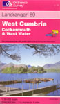
The highest peak in England situated within the Lake District National Park, West Cumbria. Unlike Ben Nevis and especially Snowdon, Scafell Pike is much less touristy than others. You have two options where to start – Wasdale Head or Seathwaite (see a map). Probably more favoured one is Wasdale Head (a track starting from either the north-eastern end of Wast Water lake [see Brackenclose] or the camp site at Wasdale Head). Although it is probably easier to get to Seathwaite from Scotland that may save total driving time, the walk takes reputedly a lot longer and navigation from that side is more difficult. We chose Wasdale Head (starting near Brackenclose) Note: When heading to Wasdale Head mind narrow roads, animals roaming or crossing the road such as sheep and last, but not least, drive carefully in residential areas. There are only a limited number of parking places on the main road near Brackenclose. Another option is to go on onwards to Wasdale Head.
Normal walking time: Scafell Pike involves 4km (2.5miles) of climbing upwards to the summit, 4km (2.5miles) downward. You have to overcome 913m (2995ft) of vertical climbing up and again down. After crossing a stone bridge over the Lingmell Beck river, pass a camping site and Brackenclose. Take an uphill climb along Lingmell Gill. Later on you will notice that your path and a path from Wasdale Head (on your left) join together. The path is relatively steep and you have to cross Lingmell Gill (no foot-bridge). Go on and when the path forks, bear left because it is not generally recommended to take path via Mickledore. Then sometimes it might not be clear where the path goes so follow cairns. At the next junction bear right for the final climb to the summit. It is reasonable to descent of the mountain using the same path. Scafell Pike mountain track from Wast Water/Wasdale Head map (scale 1:50 000), 192kB
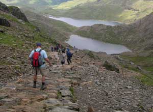
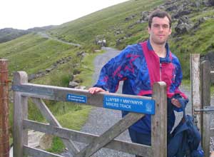
Snowdon/ Yr Wyddfa (1085m / 3560ft) Mount Snowdon (Yr Wyddfa in Welsh) is the highest peak in Wales situated within the Snowdon National Park. It can be climbed from many directions, for example from Llanberis (following Llanberis path along Snowdon Mountain Railway), Pen-y-Pass or Rhyd Ddu. However probably the best is to follow either Miners Track or Pyg Track from Pen-y-Pass. We chose Pen-y-Pass and Miners Track. Track involves 6.5km (4miles) climbing up to the summit, 6.5km (4miles) down. You have to overcome 725m (2381ft) of vertical climbing up and again down. Normal walking time: about 4:00 (see a revised 3peaks planner) Although there is a toll car park at Pen-y-Pass, it fills up very quickly during summer weekends! So that’s more than likely that you will have to drop off team members at Pen-y-Pass and then somebody (support / team member) will have to drive back to park a car either in Llanberis or near Pen-y-Gwryd Hotel. Regular local (shuttle) buses serve Llanberis (a 5 minutes ride from Nant Peris) and Pen-y-Gwryd (a 3 minutes ride). Have a look at timetables for bus routes numbers 97A, S1, S2, S3 and S4. Alternatively during day you can try to hitchhike. We left our car in Pen-y-Gwryd. Starting from the parking place at Pen-y-Pass, Miners Track leads you to Llyn Llydaw Lake. All the way to Llyn Llydaw Lake is relatively flat and track is well marked up to Glaslyn Lake. Then it’s a little bit tricky. There is a steep climb, loose shale, scree underfoot and as track is not marked properly it needn't be evident whether you climb the right way (but still if you follow a basic direction you will most likely re-join). Nevertheless it is probably better and I can recommend choosing Pyg Track instead. But back to Miners Track, when you achieve a junction with Pyg Track there are steep steps until you approach a railway. Walking up along the railway you pass the summit railway station and reach the summit. The summit is often overcrowded by tourists who arrive by train. Of course, it is not the case when you reach the summit in the middle of the night. When you get back finally to parking place you can enjoy a cup of coffee or tea at buffet at Pen-y-Pass. And don’t forget about planning to go and fetch your car if you left it somewhere away. Snowdon mountain track from Pen-Y-Pass map (scale 1:50 000), 276kB
That’s up to you to decide in which order you would climb the peaks. Most of people start with Ben Nevis, go on with Scafell Pike and end up with Snowdon. The reason is probably that Ben Nevis is considered as the toughest of the 3 peaks and therefore desirable to be left behind first. However it depends on where are you from to avoid travelling back home across entire Britain in the end and so adjust the succession accordingly. 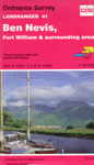
Buy/borrow relevant maps and study them in advance. You should know how to read maps. Although you will stick to regular tracks climbing up and down the peaks all the time, take a compass or GPS (global positioning system) portable device also with you. Especially encountering poor visibility you will find them invaluable. We used two kinds of maps – detailed hiking maps and a road atlas while driving.
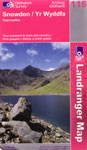
We found useful Ordnance Survey maps. In general Ordnance Survey offers, among other map series, OS Landranger Maps (1:50 000 scale; price about 6GBP each) and OS Explorer Maps (1:25 000 scale = more detailed map; price about 7GBP each) – both appropriate for 3peaks.
You may also have a look at on-line maps on the web:
Have a look at 3peaks planner calculator above. It is designed to help you to choose the most suitable start time regarding duration of all stages. Default duration times reflect approximate times one can achieve keeping brisk pace and quick, but still safe transfers. Adjust durations according to your own assessment if necessary and click “Recalculate” button. If you are interested, have also a look at our actual times in “Our Challenge Diary” section.
While planning the challenge, look up a local sunrise/sunset times for appropriate date. You can see whether a stage is going to be carried out during the day or night.
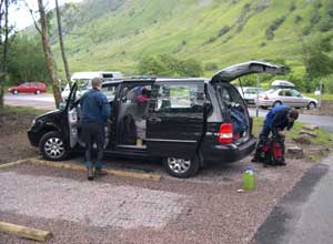
In our case we have experienced following sunrise/sunset times: Fort William (Ben Nevis) - 3JUL2004 4:35 / 22:14 Kendal (Scafell Pike) - 4JUL2004 4:44 / 21:46 Bangor (Snowdon) - 4JUL2004 4:57 / 21:45 Most likely you will transfer yourself from one peak to another by car or minivan. Consider a spacious car that is able to comfortably accommodate your team while thinking about the type of car. The bigger car you can afford, the better. It will definitely pay off! In regard to the number of team members you can come up with various scenarios whether you would use smaller cars or just a big one. Sharing just one big car for more people up to some level is probably more advantageous as you can rotate more drivers and you have lesser total fuel consumption and overall costs. On the other hand, sharing a car with many people has limitations on the fact that a car cannot go on towards the next peak until all members/teams complete an actual stage and are ready to depart. If you cannot use your own car for whatever reasons, you will probably end up in renting it from a rental company. Final choice about a rental company depends on many factors such:
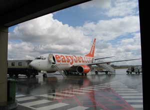
Some links: We rented a 7seater (a Ford Galaxy type) car from Europcar at Newcastle Airport. It was 310GBP for 4 days (in general we spitted costs among 5 people). I have to say that we have really appreciated our choice in regard to the car size. Actually the same applies to the rental company as well. Luckily there were no problems with the car, neither any accident. Remember - read carefully conditions and rental and insurance policy! Bring all required documents including internationally recognized driving licence with you. Check for instance:
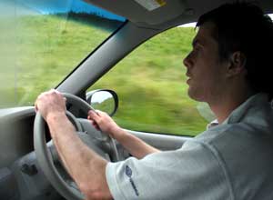
First of all, be familiar with "The Highway Code" - the official UK government guidance on correct road usage for all categories of road users. If you are interested, have a look at “Think Road Safety” page. We didn’t find any difficulties with driving in the UK. Just be prepared for narrow countryside roads, British passion for roundabouts and uncompromising parking fines even if you left your car at a pre-paid parking for a few minutes more. Our initial plan was to have a driver and a navigator and rotate those posts among all potential drivers and navigators during the night in, let say, 2 hours shifts. It would allow us to have a fresh driving couple and so enhance driving safety. Having the navigator reading a map, the driver can fully focus on driving. In general, stretch legs, make breaks or change a driver whenever you feel you are tired. However, in the end, Anthony has handled a driver role and me navigator’s one for all the 3peaks transferring time. Thanks to Anthony in the first place we haven’t experienced any problems and managed our schedule. Planning driving routes in advance I used a very handy www.viamichelin.com Route Planner. We had printed and followed detail itineraries. See a table below. Regarding Wasdale Head - Pen-Y-Pass route we decided to cross Hardknott Pass. The route was indeed spectacular, but very steep. So I wouldn’t perhaps recommend it as the best way.
Note: Use these figures as an approximate guide in your calculations. In reality, you may experience slightly different distances and times.
3peaks challenge expenses / budget Below you can find a list of major expenses. As you can see the main issue are transportation costs. We chose to rent a spacious car. We found out that the best and cheapest option was to rent a car for an entire period of our visit (= not only for from-peak-to-peak transfers). Depending on the Britain’s public transport network is both quite expensive and inflexible. So we decided to pick up and also drop off a car at Newcastle airport in the end as the best option while Anthony arranged his own transport from Snowdon back to home. In general costs may vary depending on your own plans so this is just to give you a clue (note prices reflect year 2004).
Apparently there is no need of any accommodation while rushing from one peak to another. However before and especially after the challenge you probably would like to stay somewhere to have a rest and recover. In our case we spent a night before the challenge in Edinburgh (High Street Hostel) and a night after in Snowdonia (Gwern Gôf Isaf farm). Both, we booked in advance. We preferred staying in hostel-like facilities. Therefore we didn’t look for campsites facilities nor we took tents with us. Edinburgh:
Snowdonia:
Leaving Edinburgh on Saturday we did shopping in a supermarket and bought some fresh bakery products, beverage (enough potable water in plastic bottles – at least 10 litres - the most of them left in the car, refilling empty ones at petrol stations), baguettes, candy bars, chocolate etc. along with energy drinks for drivers to keep them off sleeping. Apart from that we got some nutrition products and food supplements from our sponsor EnergUS. They are designed to help you regain energy during sport activities. Have all your food and refreshment ready before you start. Be self-sufficient as there will be no time for shopping and replenishment during the Challenge in general. Take an appropriate portion of food (bars, a sandwich, drink) with you in the rucksack while climbing each peak. Excerpt from our checklist:
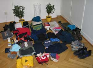
That’s up to everyone’s preferences and experience to take proper equipment with them. You may encounter windy, wet and cold conditions so you will need to be prepared and carry proper clothing and equipment in your rucksack. Weather may be volatile and unpredictable in the mountains! Keep taking off and putting on clothing layers whenever it is needed to avoid extensive sweating or hypothermia on the other hand. Have a look at hints below what outdoor equipment we used.
Our challenge diary
August 2003
Autumn/Winter 2003
March 2004
Spring 2004
May 2004
June 2004
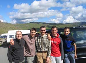
Friday, 2nd July 2004 Anthony had been already awaiting us near Europcar rental desk. Introductions were made and we picked up a car. We registered one additional driver, took keys, loaded luggage in the trunk and set out towards Edinburgh. There was plenty of space in the car. Because of Anthony, most time we have spoken English as a common language. In Edinburgh we parked in front of our hostel in the town centre, checked in and went sightseeing of Edinburgh. Later on we had a supper and dropped into the pub on the way. However we made just a pint and went into beds early.
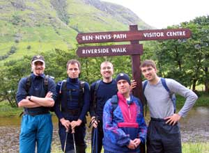
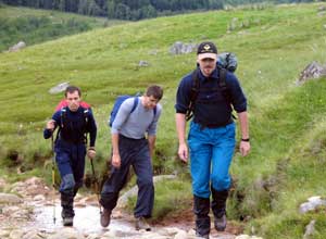
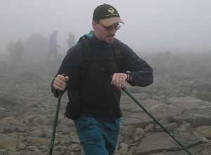
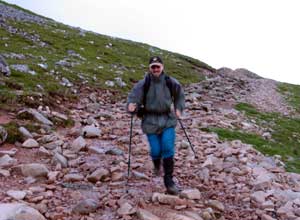
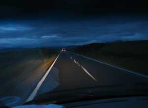
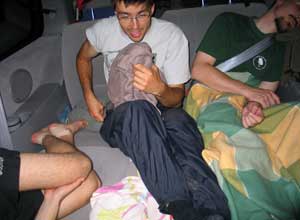
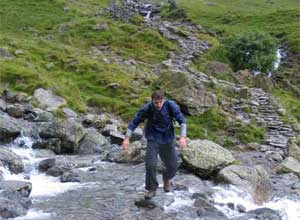
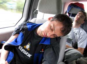
Saturday, 3rd July 2004 Around lunchtime we did shopping in the suburbs of Edinburgh and left Edinburgh area heading to Fort William. The weather was not perfect – it was drizzling but as we reached our start point at Glen Nevis visitor centre parking place, it turned to showers only. We had two hours to the start so we packed our small rucksacks, get dressed and prepared our car for overnight journey. We noticed that there was an official 3peaks event (organized by Mitchemptrust) taking place this weekend and may be a few independent groups. Most of them had already commenced. We took an initial photo and started at 18:00 crossing the bridge at the parking place. We agreed that everyone would go at one’s own pace and we would meet and wait at checking points only. So shortly we split and Anthony and me we were left the last. Luckily it was not raining. We climbed more and more steeply up, passing other walkers each other in the opposite direction. Unfortunately, as a result of rapid pace Anthony experienced some difficulties and we had to slow down. Near Meall an t-Suidhe lake it was obvious that we were not most likely going to manage the schedule keeping that speed. At that moment Anthony made a very uncomfortable decision. He decided to withdraw him from this peak letting us to complete it. Definitely it was not easy decision and I highly regarded his attitude, as he seemed undaunted. So Anthony began his descend and I kept going up. As the path zigzagged up I started overtaking some slower organized teams equipped even with a radio. The top of Ben Nevis was shrouded in mist. I guess that it could be about plus 5-10 degrees centigrade on the top. Near summit, on the snowfield, I met Vitek and later on the rest once we reached the summit at 20:15 (ascending time 2:15). We took a photo, had a snack and started our descent at 20:25 Descend is always more demanding regarding your knees and aiming one’s attention to path surface to avoid spraining ankle. I really appreciated my telescopic hiking poles. Returning back we stuck together and get to a parking place at 22:00 (descending time 1:35). We jumped into the car enjoying an instant soup Anthony had prepared in the meantime. It was getting dark slowly when we left Glen Nevis at 22:10 heading to next peak – Scaffell Pike (Wasdale Head). It was interesting to overtake or to be overtaken by quite lot vehicles full of slumbering people and outdoor gear at the beginning. The lads had reclined the rear seats so it was possible to rest comfortably quite enough. Further we drove, traffic was light owing to advanced night. However surprisingly even in Glasgow when we were filling a car up with petrol we were approached by a 3peaks team asking us what is the best way how to go through Glasgow. Anthony insisted that he was fresh enough to drive all the night as he had enough time to rest at Glen Nevis, so we appreciated it. I have been navigating but also I took an opportunity to nap on the way to Carlisle, as it was straight. Then we took ‘B’ roads again but luckily we have never got lost.
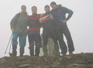
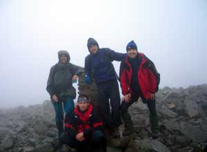
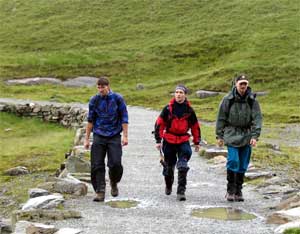
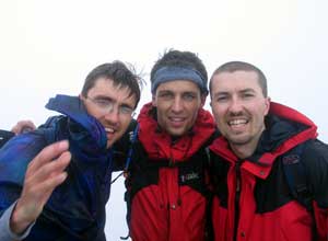
Sunday, 4th July 2004 I reached the summit at 5:15 (ascending time 1:30) awaiting the rest of my friends who appeared no longer than 15 minutes later. We took a photo and left at 5:35. At the bottom of the hill we met more teams climbing up. At 6:50 (descending time 1:15) Peter and me, we happily returned to the parking place just in time because it started raining. When Vitek and Zdenek also jumped into the car we drove off at 7:05, leaving Scafell Pike behind us. It seemed to us that going through Eskdale and over Hardknott Pass would be great idea. And it really was. But rather because of magnificent country road and a steep gradient than a significant shortcut. Later on we learned that Hardknott Pass is supposed to be the steepest road in England with an overall gradient of 1 in 3 (33%) and up to 1 in 2.5 in places. It was quite thrilling. Heading to Wales we were happy to see the sun again. Although we were afraid a little bit of a day trippers (it was Sunday), traffic was moderate. At 11:30 (driving time 4:25) we tried to find a parking spot at Pen-y-Pass car park, but it was already full at that time. We were allowed only to stop for a little while and then Anthony had to drive away and park the car near Pen-y-Gwryd Hotel junction. At 11:45 we went through a small Miners Track gate towards our last peak. It was becoming apparent that if there is no serious problem we should manage our 24 hours schedule having 6:15 hours left. It made us feeling relaxed and confident. In comparison with early morning Scafell Pike “painful” climb it was virtually a piece of cake. Snowdon summit was again hidden in clouds. We got used to the fact that there were no magnificent views on the summits that weekend. The mountains tops had transformed just into cold and windy places with poor visibility. But unlike the previous peaks the weather was decent in Snowdonia. That time Anthony joined us. We used Miners Track. The road stretched ahead across a relatively flat terrain for a few very first kilometres. Once you reached Glaslyn Lake track started rising up through loose shale ground and rocks. I reckon this was the worst track section at all regarding a type of surface. Then there were relatively easy rocky steps and junction with Llamberis Path on the ridge. Going along the railway I reached the summit station situated just a few meters below the Snowdon summit itself. It was 13:25 (ascending time 1:40). There were a lot of tourists but nobody lingered here for a long time due to weather conditions. Most of tourists came here by Snowdon mountain train. Waiting for others one had to put on another layers to keep warm. When we were ready and after we took some photos we started descent at 13:55. Climbing down we split again so I finished at 15:05 together with Petr (descending time 1:10). We did it! Our 3peaks challenge total time was 21:05. We had a cup of coffee at a car park buffet and had waited for the rest lying on the grass as the sun was finally shining again. After a while Anthony, Zdenek and Vitek marched together. It was a joyful moment. We managed it more than 2 hours ahead of the 24 hours limit. Well, we were tired but I was surprised that we still had energy. I set off for our car we had left at Pen-y-Gwryd Hotel junction. A young couple gave me a lift no longer than 5 minutes of hitchhiking. I recall that a bloke mentioned that he actually did 3peaks himself a few years ago. What a coincidence! When I fetched the car it was already possible to park at Pen-y-Pass car park as people has started leaving it afternoon. We changed our outfit and took the final picture. By the way the same man who took our start photo in Scotland took this picture. He was a support guy (a driver) for some team and we met him at every stage. It was really nice as he actively volunteered for taking photo again when he spotted us. Summing up – as a team, to be honest, we didn’t succeed due to Anthony’s uncompleted track. But on the other hand Anthony had contributed a lot as he conducted a driver role very well. So at least on the individual basis the Three Peak Challenge has been accomplished within the time limit. Nobody got lost, was injured or sick nor felt frustrated. I guess that it was thrilling experience and we had a fun (you feel always cheerful when it’s already over, don’t you?). And that’s what matters! Definitely we have got something to talk about for ages and be proud of, unless we find another demanding object of our interest to aim at … Well, having all stuff repacked we left Pen-y-Pass and went to Capel Curig. Anthony arranged his pickup by his sister and girlfriend there. They arrived just a few minutes later. So we said goodbyes and Anthony departed back home. Which was not easy, indeed, to overcome another 420 kilometres! Once we separated we went to Gwern Gôf Isaf farm (close to Capel Curig) where we planned to overnight. We had a shower and something to eat and went in bed early.
Monday, 4th July 2004
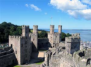
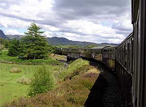
Then we took the scenic route to Porthmadog where we began our train journey (Rheilffordd Ffestiniog Railway) to Blaenau Ffestiniog and back again. Rheilffordd Ffestiniog Railway is a narrow gauge railway. Steam locomotives haul historical carriages through Snowdonia National Park scenery. The railway was restored mainly by volunteers and its passenger service is a big draw of the region. I remember we were amazed to watch old fashioned way how to ensure safety on a single-track railway - the exchange of metal tokens between the driver and the signalman. Late afternoon we visited Conwy – a small and pleasant town enclosed with town walls. The Conwy castle, which dominates the town, was already closed so we went around the town walls and strolled the inner town. Sitting on the bank of the Conwy River we enjoyed Fish and Chips and had a rest observing tide out on the mount of the Conwy River. When it started getting dark we set out on our overnight journey to Newcastle from one shore to another.
Tuesday, 5th July 2004 Google search engine
UK (mountain) weather forecast
3peaks pages
A few UK's outdoor links
Recommendation to use Code of practice: |
 Notice: Even if you are familiar with outdoor activities and mountains in particular, you should know that those activities might be dangerous. Author doesn’t take any responsibility for anyone’s follow-up. That’s at anyone’s own risk.
Please also take all environmental considerations into account, preserve nature & wildlife, obey all regulations and law enforcements and treat local people and authorities with respect. Thank you!
Notice: Even if you are familiar with outdoor activities and mountains in particular, you should know that those activities might be dangerous. Author doesn’t take any responsibility for anyone’s follow-up. That’s at anyone’s own risk.
Please also take all environmental considerations into account, preserve nature & wildlife, obey all regulations and law enforcements and treat local people and authorities with respect. Thank you!
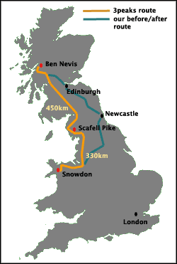 Regarding rules - there are no “official” rules. However 3peakers are supposed to start at the foot of the first hill and finish again after descent from the last peak at the foot of the hill. It involves 2963 meters (9721 feet) of vertical climbing, a walking distance of nearly 37km (24 miles) and driving about 800km (500 miles) without proper sleep or no sleep at all! Transfer among the peaks usually takes about 10-11 hours so you have got about 14-13 hours for climbing. That’s the Challenge.
 Czech
Czech
 English


 European